Size of this preview: 270 × 319 pixels.
Original file (270 × 319 pixels, file size: 56 KB, MIME type: image/png)
This is a file from the Wikimedia Commons. Information from its description page there is shown below.
Commons is a freely licensed media file repository. You can help.
Commons is a freely licensed media file repository. You can help.

|
This transport map image could be re-created using vector graphics as an SVG file. This has several advantages; see Commons:Media for cleanup for more information. If an SVG form of this image is available, please upload it and afterwards replace this template with
{{vector version available|new image name}}.It is recommended to name the SVG file “ESI map.svg”—then the template Vector version available (or Vva) does not need the new image name parameter. |
Summary
| Description |
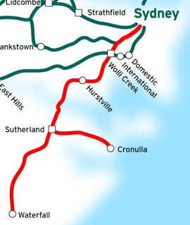
This is a map of the Eastern Suburbs & Illawarra Line in Sydney, Australia, traced on this public domain map. Original edit by NE2 |
| Date | 24 January 2007 (original upload date) |
| Source | No machine-readable source provided. Own work assumed (based on copyright claims). |
| Author | No machine-readable author provided. NE2 assumed (based on copyright claims). |
Licensing
| I, the copyright holder of this work, release this work into the public domain. This applies worldwide. In some countries this may not be legally possible; if so: I grant anyone the right to use this work for any purpose, without any conditions, unless such conditions are required by law. |
File history
Click on a date/time to view the file as it appeared at that time.
| Date/Time | Thumbnail | Dimensions | User | Comment | |
|---|---|---|---|---|---|
| current | 11:16, 11 August 2007 | | 270 × 319 (56 KB) | Vicer | This is a map of the Eastern Suburbs & Illawarra Line in Sydney, Australia, traced on this public domain map. Original edit by NE2. |
| 17:25, 24 January 2007 |  | 278 × 334 (59 KB) | NE2 | Cropped. | |
| 17:22, 24 January 2007 |  | 850 × 850 (162 KB) | NE2 | This is a map of the Eastern Suburbs & Illawarra Line in Sydney, Australia, traced on this public domain map. Category:maps |
File usage
The following page uses this file:
Global file usage
The following other wikis use this file: