Size of this preview: 456 × 480 pixels. Other resolution: 228 × 240 pixels.
Original file (456 × 480 pixels, file size: 23 KB, MIME type: image/gif, looped, 5 frames, 30 s)
This is a file from the Wikimedia Commons. Information from its description page there is shown below.
Commons is a freely licensed media file repository. You can help.
Commons is a freely licensed media file repository. You can help.

|
This map image could be re-created using vector graphics as an SVG file. This has several advantages; see Commons:Media for cleanup for more information. If an SVG form of this image is available, please upload it and afterwards replace this template with
{{vector version available|new image name}}.It is recommended to name the SVG file “Dcmapanimated.svg”—then the template Vector version available (or Vva) does not need the new image name parameter. |
Summary
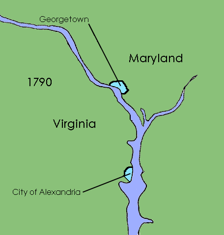
| Description | Animated map showing territorial progression of the District of Columbia |
| Date | 9 August 2008 (upload date) 17:07 (UTC) |
| Source | Own work; I created this work entirely by myself |
| Author | epicAdam (talk) |
Animation sequence
- 1790 - Area along the Potomac River prior to the settlement of the capital, including cities of Alexandria and Georgetown
- 1791 - Borders of the Territory of Columbia are defined and the City of Washington established
- 1801 - Federal district placed under the control of Congress, counties of Washington and Alexandria formed
- 1846 - 29th Congress returns the area south of the Potomac River to Virginia, see District of Columbia retrocession
- 1871 - District of Columbia Organic Act of 1871 unifies the District of Columbia into a single municipality, as it remains today
Licensing
I, the copyright holder of this work, hereby publish it under the following licenses:
This file is licensed under the Creative Commons Attribution-Share Alike 3.0 Unported license.
- You are free:
- to share – to copy, distribute and transmit the work
- to remix – to adapt the work
- Under the following conditions:
- attribution – You must give appropriate credit, provide a link to the license, and indicate if changes were made. You may do so in any reasonable manner, but not in any way that suggests the licensor endorses you or your use.
- share alike – If you remix, transform, or build upon the material, you must distribute your contributions under the same or compatible license as the original.

|
Permission is granted to copy, distribute and/or modify this document under the terms of the GNU Free Documentation License, Version 1.2 or any later version published by the Free Software Foundation; with no Invariant Sections, no Front-Cover Texts, and no Back-Cover Texts. A copy of the license is included in the section entitled GNU Free Documentation License. |
You may select the license of your choice.
File history
Click on a date/time to view the file as it appeared at that time.
| Date/Time | Thumbnail | Dimensions | User | Comment | |
|---|---|---|---|---|---|
| current | 12:26, 29 January 2009 | | 456 × 480 (23 KB) | Druffeler | == Summary == {{Information |Description=Animated map showing territorial progression of Washington, D.C. |Source=I created this work entirely by myself. |Date=17:07, 9 August 2008 (UTC) |Author=epicAdam (talk) |
File usage
The following 9 pages use this file:
- David Burnes
- District of Columbia (until 1871)
- District of Columbia Organic Act of 1801
- District of Columbia Organic Act of 1871
- District of Columbia retrocession
- History of Washington, D.C.
- User:Falcaorib/Canada, United States, Mexico, the Caribbean and Philippines
- User:Falcaorib/Washington, D.C.'s maps and photos
- Portal:Washington, D.C.
Global file usage
The following other wikis use this file:
- Usage on ar.wikipedia.org
- Usage on be.wikipedia.org
- Usage on da.wikipedia.org
- Usage on de.wikipedia.org
- Usage on et.wikipedia.org
- Usage on eu.wikipedia.org
- Usage on fr.wikipedia.org
- Usage on hy.wikipedia.org
- Usage on io.wikipedia.org
- Usage on kk.wikipedia.org
- Usage on ko.wikipedia.org
- Usage on no.wikipedia.org
- Usage on ru.wikipedia.org
- Usage on sv.wikipedia.org
- Usage on tr.wiktionary.org
- Usage on uk.wikipedia.org
- Usage on www.wikidata.org