Size of this preview: 960 × 406 pixels. Other resolution: 330 × 140 pixels.
Original file (650 × 275 pixels, file size: 123 KB, MIME type: image/jpeg)
This is a file from the Wikimedia Commons. Information from its description page there is shown below.
Commons is a freely licensed media file repository. You can help.
Commons is a freely licensed media file repository. You can help.
Summary
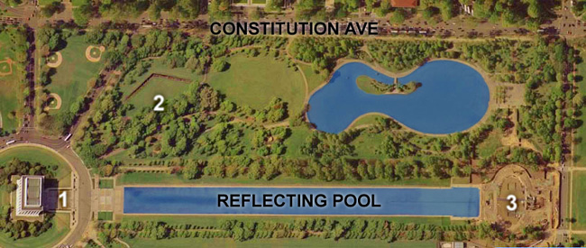
| Description | Satellite image of Constitution Gardens, Washington, D.C.. 1) Lincoln Memorial; 2) Vietnam War Memorial; 3) World War II Memorial (then-under construction). |
| Date | Satellite image taken in April 2002 |
| Source | United States Geological Survey satellite image of the National Mall in Washington, DC. Taken April 26, 2002 (see File:National Mall big satelite image.jpg). |
| Author | USGS, cropped and labelled by Postdlf |
3.reflecting pool. 2.constitution garden
Licensing
This work is in the public domain in the United States because it is a work prepared by an officer or employee of the United States Federal Government as part of that person’s official duties under the terms of Title 17, Chapter 1, Section 105 of the US Code.
Note: This only applies to original works of the Federal Government and not to the work of any individual U.S. state, territory, commonwealth, county, municipality, or any other subdivision. This template also does not apply to postage stamp designs published by the United States Postal Service since 1978. (See § 313.6(C)(1) of Compendium of U.S. Copyright Office Practices). It also does not apply to certain US coins; see The US Mint Terms of Use.
|
 | |
| This file has been identified as being free of known restrictions under copyright law, including all related and neighboring rights. | ||
File history
Click on a date/time to view the file as it appeared at that time.
| Date/Time | Thumbnail | Dimensions | User | Comment | |
|---|---|---|---|---|---|
| current | 22:27, 2 September 2007 | | 650 × 275 (123 KB) | Postdlf | == Summary == {{Information |Description=Map of Constitution Gardens, Washington, D.C. |Source=USGS satellite image |Date=Satellite image taken April 22, 2002 |Author= USGS, cropped and |
File usage
The following 5 pages use this file:
Global file usage
The following other wikis use this file:
- Usage on ba.wikipedia.org
- Usage on fr.wikipedia.org
- Usage on he.wikipedia.org
- Usage on kk.wikipedia.org
- Usage on lt.wikipedia.org
- Usage on pt.wikipedia.org
- Usage on zh.wikipedia.org