Size of this preview: 450 × 314 pixels. Other resolution: 320 × 223 pixels.
Original file (450 × 314 pixels, file size: 12 KB, MIME type: image/png)
This is a file from the Wikimedia Commons. Information from its description page there is shown below.
Commons is a freely licensed media file repository. You can help.
Commons is a freely licensed media file repository. You can help.
Summary
| Description |
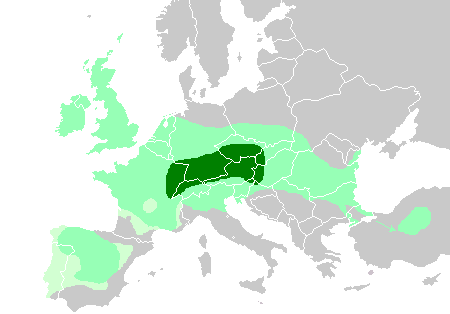
English: Maximum Celtic expansion in Europe. Based on Celts in Europe.png. This map shows:
Core Hallstatt territory, expansion before 500 BC
Maximum Celtic expansion by the 3rd century BC
Aquitanian area of Gaul, and Lusitanian area of Iberia, "Celticity" uncertain |
| Date | |
| Source | derivative of File:Celts in Europe.png |
| Author | User:QuartierLatin1968, User:Dbachmann, User:The Ogre |
Licensing
I, the copyright holder of this work, hereby publish it under the following licenses:
This file is licensed under the Creative Commons Attribution-Share Alike 3.0 Unported license.
- You are free:
- to share – to copy, distribute and transmit the work
- to remix – to adapt the work
- Under the following conditions:
- attribution – You must give appropriate credit, provide a link to the license, and indicate if changes were made. You may do so in any reasonable manner, but not in any way that suggests the licensor endorses you or your use.
- share alike – If you remix, transform, or build upon the material, you must distribute your contributions under the same or compatible license as the original.

|
Permission is granted to copy, distribute and/or modify this document under the terms of the GNU Free Documentation License, Version 1.2 or any later version published by the Free Software Foundation; with no Invariant Sections, no Front-Cover Texts, and no Back-Cover Texts. A copy of the license is included in the section entitled GNU Free Documentation License. |
You may select the license of your choice.
File history
Click on a date/time to view the file as it appeared at that time.
| Date/Time | Thumbnail | Dimensions | User | Comment | |
|---|---|---|---|---|---|
| current | 10:50, 1 June 2020 | | 450 × 314 (12 KB) | Claude Zygiel | Lighty celtic influence |
| 00:57, 6 April 2014 |  | 450 × 314 (11 KB) | Zorion | Aquitania has never been celtized. | |
| 15:40, 1 December 2009 |  | 450 × 314 (14 KB) | The Ogre | {{Information |Description={{en|1=Maximum Celtic expansion in Europe. Based on Celts in Europe.png. This map shows: *Core Hallstatt territory, expansion before 500 BC (dark green) *Maximum Celtic expansion by the 3rd century |
File usage
The following 11 pages use this file:
- Galați County
- History of Slovakia
- User:Falcaorib/Ancient Empires (300 BC-01 AD)
- User:Falcaorib/Austria-Hungary
- User:Falcaorib/Belgium, Netherlands and Luxembourg
- User:Falcaorib/France
- User:Falcaorib/Germany and Prussia
- User:Falcaorib/Italy and Roman Empire
- User:Falcaorib/Spanish and Portuguese Empires
- User:Falcaorib/United Kingdom and British Empire
- Portal:Slovakia
Global file usage
The following other wikis use this file:
- Usage on de.wikipedia.org
- Usage on fr.wikipedia.org
- Usage on hu.wikipedia.org
- Usage on kk.wikipedia.org
- Usage on ko.wikipedia.org
- Usage on nl.wikipedia.org
- Usage on pcd.wikipedia.org
- Usage on pt.wikipedia.org
- Usage on pt.wikibooks.org
- Usage on ro.wikipedia.org
- Usage on simple.wikipedia.org
- Usage on sl.wikipedia.org
- Usage on tr.wikipedia.org