


Size of this preview: 500 × 744 pixels. Other resolutions: 250 × 372 pixels | 500 × 744 pixels.

Original file (461 × 686 pixels, file size: 84 KB, MIME type: image/jpeg)

This is a file from the Wikimedia Commons. Information from its description page there is shown below.
Commons is a freely licensed media file repository. You can help.

Commons is a freely licensed media file repository. You can help.
Summary
| Description |
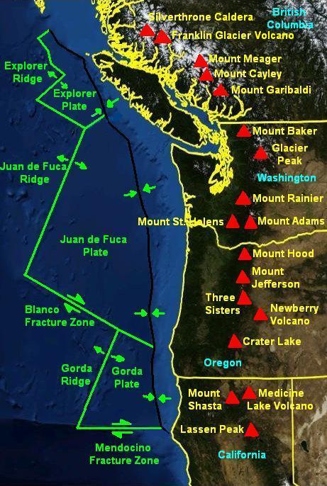
English: Map of the Cascadia Volcanic Arc. |
| Date | |
| Source |
Background: NASA World Wind |
| Author | NASA/Black Tusk |
| Permission (Reusing this file) |
NASA, public domain |
Licensing
 |
This image is in the public domain because it is a screenshot from NASA’s globe software World Wind using a public domain layer, such as Blue Marble, MODIS, Landsat, SRTM, USGS or GLOBE.
|
 |
File history
Click on a date/time to view the file as it appeared at that time.
| Date/Time | Thumbnail | Dimensions | User | Comment | |
|---|---|---|---|---|---|
| current | 23:16, 24 January 2009 | | 461 × 686 (84 KB) | Black Tusk | |
| 04:13, 17 October 2008 |  | 461 × 686 (85 KB) | Black Tusk | {{Information |Description={{en|1=Map of the Cascadia Volcanic Arc.}} |Source=NASA World Wind |Author=NASA/Black Tusk |Date=October 17, 2008 |Permission=NASA, public domain |other_versions= }} <!--{{ImageUpload|full}}--> [[Categor |
File usage
The following 6 pages use this file:
Global file usage
The following other wikis use this file:
- Usage on ca.wikipedia.org
- Usage on de.wikipedia.org
- Usage on en.wikibooks.org
- Usage on es.wikipedia.org
- Usage on fr.wikipedia.org
- Usage on he.wikipedia.org
- Usage on it.wikipedia.org
- Usage on ja.wikipedia.org
- Usage on nl.wikipedia.org
- Usage on oc.wikipedia.org
- Usage on simple.wikipedia.org
- Usage on sl.wikipedia.org
- Usage on uk.wikipedia.org
- Usage on vi.wikipedia.org
- Usage on www.wikidata.org
