Egypt is divided into seven economic regions for economic and physical planning purposes. They were formally established by Presidential Decree 495/1977, which originally partitioned the country into seven economic regions, which were later reduced to seven after the Matrouh region merged with Alexandria. These regions do not have any new administrative representation in the local government hierarchy.[1]


Instead, each region is composed of a number of contiguous governorates, with one designated as the capital of the region (that governorate's capital city).
Art. 2 established a Higher Committee for Regional Planning in each region, headed by the governor of the region's capital governorate. The committee comprises the governors, the heads of the Local Executive Councils, and the head of the national-level General Organization for Physical Planning (GOPP) as secretary-general.
Art. 3 set out a Planning Administration for each region, originally affiliated with the Ministry of Planning. In 2008, this was changed to a Regional Center for Urban Planning and Development affiliated to the GOPP.[2] However, it was later believed that planning based on these units was unrealistic, thus decentralisation efforts were put in place.[3]
| Economic region | Area (km2) | Population (2015) | GDP (billion EGP)[4] | GDP (billion US$) |
|---|---|---|---|---|
| Greater Cairo | 17,342 | 21,969,529 | 2,986.037 | 190.211 |
| Alexandria | 224,076 | 11,064,294 | 970.284 | 61.807 |
| Suez Canal | 90,020 | 9,555,718 | 902.566 | 57.493 |
| Delta | 12,357 | 19,145,755 | 886.439 | 56.467 |
| South Upper Egypt | 216,212 | 10,573,686 | 386.923 | 24.647 |
| North Upper Egypt | 47,970 | 11,183,684 | 351.674 | 22.402 |
| Central Upper Egypt | 402,431 | 4,470,631 | 143.106 | 9.116 |
| 1,010,408 | 94,798.827 | 6,627.028 | 422.142 | |
Economic regions
editThere are seven regional units, containing the following governorates.[5][1][2] In 2014, there were discussions to expand them to eleven regions, but those plans never happened.[6]
The current structure is as follows:
| Economic Region | Governorates | Capital |
|---|---|---|
| Greater Cairo[7] | Cairo, Giza, Qalyubiyya | Cairo |
| Alexandria[8] | Alexandria, Beheira, Matrouh | Alexandria |
| Delta[9] | Dakahlia, Damietta, Gharbia, Kafr El Sheikh, Monufia | Tanta |
| Suez Canal[10] | Ismailia, North Sinai, Port Said, Sharqia, Suez, South Sinai | Ismailia |
| North Upper Egypt[11] | Beni Suef, Faiyum, Minya | Minya |
| Central Upper Egypt[12] | Asyut, New Valley | Asyut |
| South Upper Egypt[13] | Aswan, Luxor, Qena, Red Sea, Sohag | Aswan |
Gallery
edit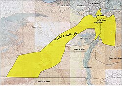 Greater Cairo Region
 Alexandria Region
 Delta Region
 Suez Canal Region
 North Upper Egypt Region
 Central Upper Egypt Region
 South Upper Egypt Region


See also
editReferences
edit- 1 2 "Presidential Decree 495/1977". The Official Gazette. 1977. Archived from the original on 2023-02-24. Retrieved 2023-02-24.
- 1 2 "Regional Center of the General Authority for Urban Planning - Tadamun". Retrieved 2023-02-24.
- ↑ Piffero, Elena (2009). What Happened to Participation? Urban Development and Authoritarian Upgrading in Cairo's Informal Neighbourhoods. Odoya srl. ISBN 9788896026182. Archived from the original on 4 November 2016. Retrieved 3 November 2016.
- ↑ "GDP BY GOVERNORATE", mped.gov.eg
- ↑ "Government of Egypt, General Organization for Physical Planning (with map)" (in Arabic). Archived from the original on 2017-07-05. Retrieved 2016-10-20.
- ↑ Leila, Reem (July 10, 2014). "Remapping Egypt". Al-Ahram Weekly. Archived from the original on 4 November 2016. Retrieved 2 November 2016.
- ↑ "Greater Cairo region Map". General Organization for Physical Planning (GOPP). Archived from the original on 14 April 2023. Retrieved 28 October 2016.
- ↑ "Province of Alexandria Map". General Organization for Physical Planning (GOPP). Archived from the original on 28 October 2016. Retrieved 28 October 2016.
- ↑ "Delta Province Map". General Organization for Physical Planning (GOPP). Archived from the original on 2 December 2020. Retrieved 28 October 2016.
- ↑ "Suez Canal Region Map". General Organization for Physical Planning (GOPP). Retrieved 28 October 2016.[permanent dead link]
- ↑ "North Upper Egypt Province Map". General Organization for Physical Planning (GOPP). Retrieved 28 October 2016.[permanent dead link]
- ↑ "Assiut province Map". GOPP Gov Egypt. Retrieved 28 October 2016.[permanent dead link]
- ↑ "South Upper Egypt Province Map". General Organization for Physical Planning (GOPP). Retrieved 28 October 2016.[permanent dead link]